
Exhibitions and Projects 2017
South Dorset Ridgeway interpretation commission
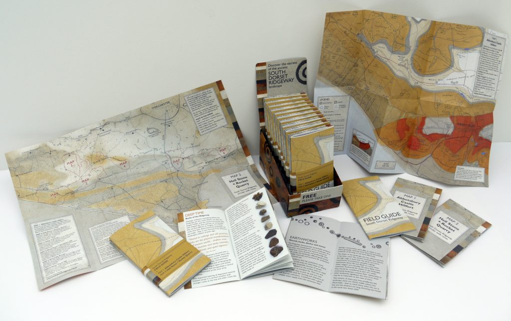
Hooray – The Field Guide and the first two maps exploring the landscape of the South Dorset Ridgeway have now been printed and are being distributed to TIC’s and other local outlets. These first two maps show walking routes in the Abbotsbury and Portesham area. A further four maps with routes exploring the Valley of Stones, Black Down, Bronkham Hill, Bincombe and Ridgeway above Sutton Poyntz will be available in the autumn.
The concept behind the Field Guide and maps is to highlight how the unseen geology beneath our feet dictates or influences the landscape we see today. From landforms, soil, plants, wildlife and early human intervention – all relate to the rocks below the surface. The colours on the maps indicate the type of rock and its age of formation. In contrast to geological maps that use a universal colour coding system, I have used colours that approximate the actual colours of the rocks – a link to my Colour of Time work. The maps also show prehistoric sites – this area has an astonishing range, field boundaries – including the names of fields where known, and other notable features. The accompanying Field Guide gives an introduction to this remarkable landscape and some of the things to look out for.
This project has enabled me to incorporate a long-term interest in maps, walking, routes, trackways archaeology and geology, bringing together ideas of the physical experience of landscape and the presence of the past with notions of rocks as vast data stores recording everything.
The Guide and maps come as a package and are a handy-pocket – about the size of a smart phone – the maps fold out to A3 and are laminated. They are FREE so get one while you can.
The walk routes themselves were devised by the team at Dorset Area of Outstanding Natural Beauty and Rangers from the County Council’s Countryside team who look after this landscape.
Thank you – Sam Scriven and Richard Edmonds for awakening my innate interest in geology and inspiring my approach to this project. Also thank you to Claire Pinder and Steve Wallis for fuelling my passion for all things prehistoric, Andy Elliot and Stacey Vanstone of Dorset County Councils GIS team for their mapping support and Simon Barber for design work.
And a big thank you to the South Dorset Ridgeway Partnership for the commission.
OPEN STUDIO
I will be showing research work and work in progress for the above project at my Open Studio event in September – details below.
Amanda Wallwork – Open Studio
Sat 9, Sun 10, Wed 13, Thur 14, Fri 15, Sat 16, Sun 17 September
11am – 5pm (other times by appointment)
Showing painting and other work concerned with archaeology, geology and formation of landscape – revealing what is not always immediately apparent, what can’t always be seen on the surface.
Includes research and work in progress on recently commissioned series of maps and Field Guide exploring the landscape of the South Dorset Ridgeway.
Top Floor Studio, The Old Timberyard, West Bay, Bridport, Dorset DT6 4EL
Directions & parking:
Take the road to West Bay from Bridport, go straight over the mini-roundabout by Haddon House Hotel and turn into the Old Timberyard gateway on the right just before George Street. Parking available in yard or car park opposite.